|
|
|
|
Thread OP
|
Discussion
Perth Slope Soaring
I've just moved to Perth, and need help finding a place to do some slope soaring.
I've spent hours searching RC groups and the rest of the net for clues, but can't find any up-to-date recommendations for a good site. It seems that the old sites may have been turned into housing estates (urban sprawl strikes again). Last weekend I visited 2 RC clubs and asked some locals, but when I used the words "Slope Soaring", they looked at me as though I'd just sprouted an extra head (I checked, and I hadn't). The best site I've found so far is Lancelin, but that's nothing special. I also flew off Shelly beach in Albany last weekend, and although it has lots of potential, when the wind picks up...I can imagine it's going to get crowded with hang gliders. I refuse to believe that with all this coastal area and good winds, that there's nowhere to throw a plane off a slope. Any advice ? UPDATE : To save people the hastle of reading through this entire thread for info, I'll try to summerise (and give some extra details) of what we've found so far. GOOGLE EARTH OVER VIEW  GOOGLE EARTH DETAILED IMAGES     IDEAL WIND DIRECTIONS  HERE'S AN UPDATED VERSION IN PDF OF IDEAL WIND DIRECTIONS DTWaa AVERAGE HISTORICAL WIND DIRECTION AND STRENGTH (FOR PERTH CBD @ 3 PM SINCE 1942)             ************************************************** ***** PERTH SUBURBAN SITES : ************************************************** ***** WUNGONG DAM (front wall) (See posts # 33, 63 & 66) Wungong Dam   This place is good, I flew here in 20 knot winds and the lift was awesome. Being such a large structure, the lift extends well forward and up to a crazy height. I only flew a small foamy, but I think larger planes would love it here, but larger planes would attract the attention of the Rangers. Strangely, it can get a little turbulant on the front side, depending on wind direction. If you want to fly here, have a chat to the Wungong Dam Park Ranger (Phone 93992212, although you'll probably get an answering machine, I just kept calling at different times, until someone picked up). The Ranger was happy to give me permission to fly, and I believe that was because I managed to convince him that he was not taking a risk by saying YES. If you call, It'll help a lot if you: - have MAAA insurance (let him know it includes Personal, Public liability and Corporate insurance). - are willing to only fly on week days to avoid people, - fly only small light foamies, - sound like you're somebody who knows what they're doing and can be trusted. - make it clear that it has no motor and is therefore silent with no polution, - make it clear that there's no fire risk in the event of a crash due to the tiny Nimh battery, - let them know that you wont scare the wild life, - let them know that onlookers find it fascinating to watch, and are happy to see you fly. - I also invited to teach him to fly if he wanted to learn. My rating - 6/10 UBD map - 413 N9 Type - Rocky 45 degree Dam wall 200 feet high Access to the top of the wall - Easy, park and fly Ideal wind direction - North Westerly Landing area - Concrete/Bituman dual lane road (foot trafic only), If you land behind the road there is a small rocky area that may save you're plane before it's in the water. If you're forced to land in front of the wall, there appears to be many accessable flat areas (I'll let you know for sure once I crash there). Hazards - Area is shared with tourists, and the rocky wall is very unstable (walking down the rocky bank is prohibited and a really bad idea, so avoid landing on the bank at all cost), landing area (road) is concrete and Bituman. Edit; Landings can be tricky if you get it wrong, as the plane gets kicked around due to the turbulance and rotors at the back of the road. A couple of times I saw my DIU make what looked like a nice approach, only to be flipped over onto its back, then flicked out towards the back wall. So just land on the front of the road 'till you figure it out. Heavier planes wont be affected as much. ************************************************** WUNGONG DAM (back wall) (See post # 43) Wungong Dam   The first time I flew here, the cold wind made my face go numb, but I was very impressed by this place, the lift was awesome. I think this would be a good spot to do some Dynamic Soaring. Edit: I just spent a few hours DSing this place, and it really is good. The only things I don't like are, the road landings scratch up my planes, and there are some nasty rotors to deal with. I also had to climb down the wall about 50 meters to retrieve a plane, and it's not fun, the loose rocks make it dangerous. And the lift on the front side wasn't as awesome as I remembered, it was enough to get enough height to drop in for a DS circuit, but that's about it really. Edit; I spent a bit more time here today, and found this placeto be a bit unpredictable. Today the winds were consistently in the right direction, but the amount af turbulance and lift seemed to vary with no correlation to the wind speed. There must be "unseen" forces at work here, that I can't figure out. At times the lift was strong and smooth, then ten minutes later our planes were getting hammered by turbulance. My rating - 6/10 UBD map - 413 N9 Type - Rocky 45 degree Dam wall 40 feet high Access to the top of the wall - Easy, park and fly Ideal wind direction - South Easterly Landing area - Concrete dual lane road (foot trafic only), Hazards - Area is shared with tourists, and the rocky wall is unstable, landing area is concrete and Bituman, and look out for rotors on the dark side (not that you can see them). ************************************************** WATERLAND POINT (see post #49) Waterland Point   Nice clean sea breeze. The low slope angle (30 degrees) made it difficult for my unbalasted foamies to penetrate, so bring lots of balast. The Crunchies I flew with were much better suited to this type of slope, given enough wind. I really enjoyed flying here, but I need a more suitable plane. I got to fly here with a strong WNW (not ideal) but it still provided good lift. Edit - Flew here in ideal conditions (WSW 20 knot winds), and it was excellent, heaps of clean lift stretching out 100 meters over the ocean, 100 meters up and you could probably fly along the dunes until you ran out of TX range.... it's a big area to fly in. My rating - 5/10 UBD map - 104 C9 Type - Sand dunes 30 degree 50 feet high Access to the launch site - Easy- park, walk 100 feet and fly Ideal wind direction - West South West Landing area - Mix of sand and scrub Hazards - Area is shared with people and dogs, especially tricky if you fly down low over the beach. You can't see the isolated (read dodgy looking) car park from the launch site. ************************************************** MULLALOO BEACH Mullaloo   Fun little site, needs a good westerly. ************************************************** WANGARA INDUSTRIAL AREA(see post #15) Wangara Industrial Area   This place is actually pretty cool. Most times that I've flown here, the wind's has been weak, but if you bring a small foamy (Alula type thingy) you'll have some fun. One of the pictures shows Brad (3dfly) slope soaring for the very first time (and showing me how it should be done), so it's not a bad place to learn, but more lift would make it easier on a novice. More experienced pilots may also like flying here, as low lift days tend to force you to fly more efficiently. It looks like this site can be flown from almost any wind angle, but South looks the best, followed by West. This site may not be around for too much longer, as buildings are cropping up all around it, and the land is probably worth a bit now. Edit; got to fly here again in reasonable conditions (Westerly @ about 10 knots), and it was heaps of fun, although, sadly, I did notice that when the Westerly winds pick up strength, the turbulance from the surounding buildings does become an issue. But don't let that stop you. Edit; PJM brought a DLG (I love acronyms) here the other day, and it was brilliant. It made our litlle foamies look like the toys that they really are. I gotta get a DLG. Another Edit; I got to fly the South face the other day, and it was.... alright. Lift isn't as good as it looks like it should be, even with a strong wind. There's also a lot of turbulance (and sink) from the buildings and structures in front, and there's some pockets of dead air if you venture below the horizon. Last Edit ever; As I found out today, if you go here when they're working in the area, you will be kicked off the site. There's no point in arguing with them as they are totally in the right... if they allow you to fly, they're accepting liability (and that would just be a stupid thing for them to accept). They work here every week day and on Saturday until about 3pm. My rating - 5/10 UBD map - 188 E5 Type - Peat mound 45 degree 50 feet high Access to the launch site - Climb 50 feet straight up the slope and fly Ideal wind direction - South or West, but any strong wind from any direction should be flyable, as the mound is basically square. Landing area - Really good, no trees, not many rocks, just seasonal tall grass at the moment to soften the blow. Hazards - It's in a developing industrial area, so any flying during business hours would just be begging to have the area fenced off. Also, in some parts the "ground" is very soft and loosely compacted, so if you walk near the edge, you may find yourself on your butt, sliding down the slope. Also, walking on the soft dirt gets your shoes and socks very dirty, I have to wash my sneakers, and throw away my socks after every visit, so enclosed work boots would be a smart move. ************************************************** SAFETY BAY Safety Bay   Nothing about this place is HUGE, but with a good wind it is heaps of fun, and a great place to learn or just muck around on the front side. It's gotta be one of the most picturesque flying spots around. The bay stretches around in such a way that if the wind's not in the ideal direction, you just move up the coast a bit until it is. I'm not sure if I found the "mythical" third car park or not, but I did find dozens of flyable sites all along the bay. My rating - 5/10 UBD map - Stretches from 465 J12 to 475 N13 Type - Sand dunes 45 to 90 degrees 20 to 50 feet high Access to the launch site - Easy, park and fly Ideal wind direction - Anything from West to South West Landing area - Small scrub and dunes. Hazards - Snakes and in some spots you have to fly very close to roads and houses. ************************************************** CLAYTONS/MINDARIE BEACH Mindarie   The advantage of a beach slope is the nice clean (not turbulant) wind. It looks like it could be fun, there was only a light sea breeze blowing when I tried it, I didn't have much luck with a small plane. I'll definately go back when the wind picks up. I was told today that this site is regularly used by local slopers. I think this place will be similar to Waterland Point, in that the low angled lift will be more suited to a composite than to a foamie, as foamies will have trouble penetrating (but they'd still be fun to fly). My rating - looks like a 5/10 UBD map - 124 J11 Type - Sand dunes 45 degree 40 feet high Access to the launch site - Easy, park, walk 100 feet and fly Ideal wind direction - West South West Landing area - Some sort of white, granular chrystaline substance. Hazards - Area is shared with beach type people. ************************************************** ***** LES MURDIE FALLS Lesmurdie Falls   Pretty good actually, there are lots of places to fly from, facing West +/- 90 degrees. The lookouts over the falls would be excellent with a good WSW, but you need to be brave as recovery is always going to be a problem. My rating - looks like a 4/10 UBD map - 292 Q15 Type - Scrub 30 degree 150 feet high Access to the launch site - walk 1/2 km along track and fly Ideal wind direction - I saw sites that can be flown in everything from South to West to North, if you're prepared to walk a bit. Landing area - Thick scrub. Hazards - Snakes. ************************************************** WATERMANS BAY Watermans Bay   Thanks Graham (Lert) for showing me this place. It's one of those rare isolated spots in the middle of a busy area. You could probably fly here unnoticed by the general public. Lift isn't bad for such a small cliff, but it's really only suitable for small foamies. My rating - 3.5/10 UBD map - 205 N16 Type - Mix of scrub and Jagged rocks over the ocean, 50 to 90 degree 30 feet high Access to the launch site - Easy, park and fly Ideal wind direction - WSW Landing area - Pretty easy, land near the walking track or in the scrub. Hazards - - You'll be flying right in front of the Marine Research Facility, so if you get blown back you may land on their roof. Or you can fly to the left of the Facility over gentle slopes as shown in one of the pictures above, where the re-vegitation area and snakes are the only real hazards. This place has the most aggressive sea gulls I've ever seen !!! ************************************************** BURNS BEACH/DUNES Burns Beach Dunes   (Thanks SlopePerth) I really didn't like this place much at first, to get to the slope shown in the second picture, it's an exhausting walk along the dunes. Lift is just OK and a bit turbulent. There are no good landing areas and I had to crab approach the LZ through sink and rotors while on the edge of stalling... most times it doesn't end well. Edit: Now that I've flown here a few times, I like it a bit more. DSing is possible (but you're flying around a group of trees that eat planes). Not a friendly place to fly, but at least it can be flown on a Southerly wind. This place will be flattened soon as the developers move in. Edit: Having flown here a lot lately, I now think it's one of the most difficult, but best DS sites in Perth. The dunes inland of the beach are a fantastic place to DS from, although it's an extremely technical place to fly (what with all the trees and rotors and basically filthy air on the darkside), it's very rewarding when you learn to get it right and it hones your skills like no other place I've ever flown. PJM with his molded glider 129mph PJM again with TSnake's Skua at 99mph (unofficially the 2nd fastest in the world) plane sailing with his Typhoon 97mph plane sailing with his Speedo 76mph (unofficially the 4th fastest in Australia) TSnake with his Skua foamy at 74mph metamorphesis with his Luna 68mph Kaffine with his Bat 57mph ************************************************** NORTH BEACH North Beach   I did fly here, and it was OK, but it's one of those places that makes you feel like you're breaking the law and are going to get challenged at any second. Plus you're flying over dune re-vegitation areas, so according to Murphy's law, you will eventually have to tread all over their precious weeds to retrieve your plane. My rating - 3/10 UBD map - 225 N02 Type - Mix of scrub and Jagged rocks over the ocean, 25 to 50 degree 40 feet high Access to the launch site - Easy, park and fly Ideal wind direction - West Landing area - In the car park or on a trail. Hazards - Area is shared with children, joggers, bicycles, dogs, cats, birds, snakes, insects, cars, it's close to houses and a busy road.... but other than that, it's very peacefull. ") Too many distractions for me, but if you can handle drawing a crowd of curious spectators, you may like this place. ************************************************** MOUNTAIN QUARRY in Boya (see post # 28) Mountain Quarry   This site may be a bit better than Stratham's, it's higher and the air may be a little less disturbed. But, it was still very turbulant and patchy lift, again not much fun at the moment. I hope things will improve as the weather heats up. Rating - 2.5/10, but I'm hoping it'll improve in summer UBD map - 253 L10 Type - 100+ foot vertical rock cliff (abandoned Quarry) Access to cliff's edge - On the North Westerly side, there's a goat track leading to the top. This track is very dangerous as it takes you within inches from the edge and is slippery in the wet. The road/track to the South Easterly side has relatively easy access, but can be slippery. Ideal wind direction - South Westerly Landing area - Small shrubs, rocks and trees, no clear areas. Hazards - Falling rocks, site regularly used by rock climbers, top of cliff has no barriers/guard rails, area is slippery when wet, North Westerly access track to the top may scare the %$@# out of you, so use the South Easterly track. Both these sites (Mountain Quarry and Stratham's Quarry) are controled by the Department of Environment and Conservation, a quick and very polite phone call to the lovely Marie Milagro will get you permission to fly either site and the code to open the lock on the gate. They need to maintain some control over these sites, so they can limit the numbers to 40ish people at any given time. Additionally, they want to know who to phone if there's an emergency (i.e. if a scrub fire is approaching the area, they may need to evacuate the area quickly). So please don't just "show up and fly". Marie Milagro Perth Hills National Parks Centre Allen Road, Mundaring, 6073 9295 2244 Edit- I got to fly both Quarrys today, and at this stage I've gotta say that Mountain Quarry is much better than Stratham's (see post # 28). Edit - I flew Mountain Quarry again the following day, and it was no better than Stratham's !! .... so I just don't know anymore. Maybe I'm just flying at the wrong time of the year, I may go back when the rocks warm up. ************************************************** STRATHAM'S QUARRY in Gooseberry hill (see post # 28) Strathams Quarry   When I flew here it had very turbulant and patchy lift, it wasn't much fun. It may get better in the warmer months when the rocks warm up and provide some thermal help. Rating - 2/10, but I'm hoping it'll improve in summer UBD map - 273 F3 Type - 80 foot vertical rock cliff (abandoned Quarry) Access to cliff's edge - An easy and safe trail/stairs. Ideal wind direction - Westerly Landing area - Small shrubs and rocks, no clear areas. Hazards - Falling rocks, site regularly used by rock climbers, top of cliff has no barriers/guard rails, area is slippery when wet. ************************************************** BICKLEY BROOK RESERVOIR Bickley Brook   The area behind the carpark is flyable, but I wouldn't bother going back here, unless you want to take the family out for a picnic while you flutter about. No serious flying here. You can't fly off the small dam in the pictures because it's completely surounded by RAZOR WIRE !!! I kid you not. Rating - 2/10 UBD map - 313 B14 Type - 40 foot 30 degree slope Access launch site- Easy, park and fly. Ideal wind direction - NNW Landing area - scattered small shrubs and rocks Hazards - Snakes. ************************************************** LION'S LOOKOUT in Lesmurdie Lion's Lookout   I'm told some locals fly here. It's not a very big site. Even on it's best day I'm sure there wont be much lift, but if you want to teach yourself to slope, or maybe just glide test a plane, it may be just what you're looking for. There may be other places to fly from in the area, but I didn't explore all the tracks. Rating - 2/10 UBD map - 313 A6 Type - 40 foot 30 degree slope Access launch site- Easy, park and fly. Ideal wind direction - WNW Landing area - scattered small shrubs and rocks, with some small patches of clear area. Hazards - It's a public lookout, power lines and a busy road below. ************************************************** SALTER POINT(see post #53) Salter Point 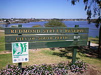  (Thanks mr_meks) I've been told by a couple of people that they fly from here, I'm not able to rate it as I'm too scared to try it. You'll be flying directly over tall trees and thick scrub, they tend to mess up the lift and grab your plane if you loose altitude. Also, if you fly a bit further out to get away from the trees, you'll be flying over water. It's a very small public reserve (no bigger than an average sized block of land) surounded by, a school, a road and houses. UBD map - 308 N13 Ideal wind direction - South to SSW ************************************************** ***** I HAVEN'T FLOWN THESE SITES YET ************************************************** ***** THE MYSTERY SPOT in Boya (see post # 12) Mystery spot  My rating - looks like a 2/10 UBD map - 253 M14 Type - 40 foot vertical rock cliff (abandoned Quarry) Access to cliff's edge - No easy access, scrub with no direct paths. Hazards - Falling rocks, possibly shared with rock climbers, top of cliff has no barriers/guard rails, area is slippery when wet, snakes.... I know they're there. ************************************************** GARDEN ISLAND (see post # 18) Garden Island   UBD map - 443 D10 I don't own a boat, so I'm not able to explore the Island. Public access to the island has been restricted to daylight hours, although over 80 percent of the island is still open to the public. Only accessible by sea via private boat under curfew conditions. The island is classified as an A-class reserve, and the Navy has undertaken various successful programmes for the removal of introduced animals; all native animals on the island are protected. This last point alone, may prevent slope soaring on the Island, for environmental protection reasons. We need more information. ************************************************** MUNDARING WEIR DAM(see post #33) Mundaring Weir 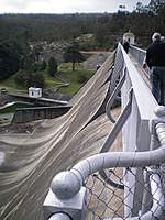  Looks pretty extreme doesn't it ? I haven't asked for permission to fly here yet, and I doubt I ever will. Because even if I was allowed to fly here.... I wouldn't. There are far too many tourists clogging up the walkways and making the place look untidy, it's far too easy to lose a plane over the back, and landing is near impossible....But other than that it's great ! ************************************************** POINT PERRON Point Peron  Surely someone must know something about this place ? ************************************************** LOGUE BROOK DAM Logue Brook Dam  I've been told that this is a really good place to fly. Ideal wind direction - WSW (front) and ENE (back) ************************************************** CANNING DAM(see posts #33 & 51) Canning Dam  This place is hugely massive in its bigness, I'll look into flying here one day. ************************************************** MOUNT CUTHBERT Mount Cuthbert  It looks like hard work just getting to the top, may make an interesting day trip. ************************************************** WELLINGTON DAM Wellington Weir   ************************************************** NEW VICTORIA DAM Victoria Dam  Ideal wind direction - NNW (front) and SSE (back) ************************************************** OLD VICTORIA DAM WALL Old Victoria Dam  I've only seen pictures, but I like the look of this place. The Old Wall looks isolated from the public. Ideal wind direction - NW (front) and SE (back) ************************************************** BARRINGTON-GOSNELLS QUARRY BARRINGTON-GOSNELLS QUARR...   Yet another abandoned old Quarry, going to waste. ************************************************** ELLIS BROOK FALLS Ellis Brook  I only know that people have access to this place via an old walking trail. ************************************************** BLACK WALL REACH Blackwall Reach  limestone cliffs on the Swan River. This is a rock climbers spot that may be flyable, I haven't seen it yet. To get to the Black Wall Reach Parade parking spots follow Pt Walter Road and turn left onto Beach Street and take a right onto Black Wall Reach Parade. ************************************************** WILBINGA DUNES near Two Rocks Wilbinga Dunes   ************************************************** NORTH DANDALUP DAM Dandalup Dam   ************************************************** CY O'Connor Beach CY Oconnor 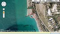 (Thanks Goody63) (near the old Fremantle Power Station) I haven't seen this place myself, but to quote Goody63: "Definetly a howling SW spot though the slope/beach south (towards the old power station) looks like it would be good in a Westerly. I parked in a carpark South of that spot on Robb Rd and then walked the 200m or so along the cycle path up to the spot." ************************************************** YALLINGUP YALLINGUP  (Thanks Jezaroony) Fly from the comfort of a conveniently placed park bench. ************************************************** WARNBRO SOUND Warnbro Sound 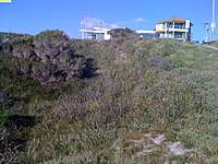 Warnbro 3rd Carpark *WSW-WNW (thanks Goody63) ************************************************** MOSMAN BAY -MINIM COVE PARK Minim Cove Park  I heard that the local council is not happy letting slope soarers fly here, but people do anyway and say it's a great site. ************************************************** MULLALOO LOOKOUT Mullaloo Lookout  ************************************************** FLOREAT BEACH FLOREAT BEACH  ************************************************** ZIG ZAG Zig Zag  ************************************************** OUTSIDE PERTH SUBURBAN AREA : ************************************************** ***** ESPERANCE "THE BOWL"Observatory Point Esperance   Magnificent place to fly and nobody bothers you. Lift is clean and strong and recovery from the beach below is actually possible. I love this place, I just wish it wasn't so far away. My rating - 8.5/10 UBD map - Out of map limits, 880ish kilometres south east of Perth Type - 120+ foot cliff over the sea Access to cliff's edge - Easy, park, walk down path and fly Ideal wind direction - SE for slope soaring over the beach Landing area - Excellent, small shrubs no rocks Hazards - Sun and wind burn and the danger of your head exploding because you're having too much fun ************************************************** ALBANY WIND TOWER 1 Albany Windfarm   Looks absolutely great for Dynamic Soaring, the back side is huge and un-cluttered. The only problem is the tourists (that's what stopped me flying here). My rating - 7/10 UBD map - Out of map limits, 500ish kilometres south of Perth Type - 100+ foot slope perfect for DSing with a NW Access to cliff's edge - Easy, park, walk up path and fly Ideal wind direction - NW for DSing or SW for slope soaring over the beach Landing area - Small shrubs Hazards - Area is shared with too many tourists ************************************************** SHELLEY BEACH in Albany SHELLEYS   My rating - looks like an 7/10 UBD map - Out of map limits, 500ish kilometres south of Perth Type - 60 - 100 foot slope down to the sea Access to cliff's edge - Easy, park and fly Ideal wind direction - ? Landing area - Small shrubs and rocks, Hazards - Area is shared with tourists and Hang gliders. ************************************************** LANCELIN (Beach) Lancelin Dunes  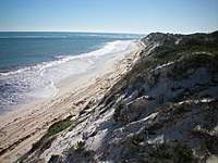 The beach and dune area has been designated as a 4WD recreational area, so very few rules seem to apply here. Lancelin is known as one of the best windsurfing and kitesurfing locations on planet Earth, so slope soaring should be possible if you can find a suitable spot. I've only spent a couple of hours here, but was able to easily find one site, even though the winds were light and not from the ideal direction... I had a blast with a light plane and even managed to fly a Wowings Booby. I will return. Rating - looks like a 5/10 UBD map - Out of map limits, 130 kilometres north of Perth Type - 30 foot high, 30 - 60 degree sand dunes on beach with 2WD access to within 1 km of site Access to launch area - Easy access Ideal wind direction - SW Landing area -Soft fluffy sand Hazards - Sun/wind burn, 4WDs and motorcycles use the area for recreation ************************************************** LANCELIN (Dunes) Lancelin Dunes   I don't own a 4wd, so I wasn't able to explore the dunes. But from all the pictures I've seen of this area, there may be an excellent site hiding in there somewhere. But there would have to be heaps of separation between the dunes, otherwise you would be in the "shadow" of the dune in front, and that wouldn't work. We need more information. Edit; I was told by a local flyer today that there is a dune that can be accessed from the car park (at the foot of the dunes) that is really good for some DSing, given the right winds (sorry I don't know what they are). CONTINUED ON POST #3 (There's a limit to the number of images per single post) |
|
|
Last edited by TSnake; Dec 10, 2010 at 08:19 AM.
Reason: tO MakE iT gOOdEr
|
|
|
|
|
|
|
|
I have not read the Perth slope threads as the spots are a bit far but I have seen pics of a spot they hold a slope race event each year.
Here are some links, hope they help. https://www.rcgroups.com/forums/showthread.php?t=541266 https://www.rcgroups.com/forums/showthread.php?t=559174 Andrew |
|
|
|
|
|
|
|
Thread OP
|
************************************************** *****
I HAVEN'T FLOWN THESE SITES YET ************************************************** ***** KALBARRI CLIFFS Kalbarri   Looks amazing, it's North of Geraldton. ************************************************** ***** CAPE HOWE Cape Howe 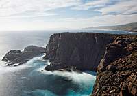  ************************************************** DENMARK Denmark  ************************************************** TWO PEOPLES BAY (near Albany) Two Peoples Bay  ************************************************** CAPE D'ENTRECASEAUX CLIFFS (near Albany) Cape D'Entrecasteaux Clif...  ************************************************** BLUFF KNOLL -STIRLING RANGE (near Albany) Bluff Knoll   ************************************************** BREAKSEA ISLAND LIGHTHOUSE (near Albany) Breaksea Island  ************************************************** CONTO'S Contos  Conto's is 15km out of Margaret River big slope big lift ************************************************** Other possible sites that I have no information about : Dalkeith -Bishop Road Park Bishop Rd Park Dalkeith Darlington Boulders Darlington Boulders Drakesbrook Dam Drakesbrook Dam Brockman Dam Brockman Dam Waroona Dam Waroona Dam Harris Dam Harris Dam Back Beach Back Beach Ocean Reef Ocean Reef South Cottesloe/North Leighton Cottesloe Churchmans Brook Dam Churchmans Brook Dam Toodyay Boulders Toodyay Kalamunda National Park Boulders Kalamunda National Park B... Serpentine River/Dam ? Serpentine Dam South Dandalup Dam South Dandalup Dam Trigg Bushland Reserve Trigg Bushland Harvey Dam Harvey Dam Bells rapids Brigadoon Bells Rapids Cataby roadhouse Cataby Seabird towards Moore River Seabird Reabold Hill Reabold Hill Halls Head Halls Head Waikiki (opp short st *Southwest wind*) Waikiki Honeymoon Pool cliff Honeymoon Pool cliff Peppermint Grove cliffs Peppermint Grove Port Gregory and Greenough Port Gregory Cockburn power boat club ? Cockburns Powerboat Mount Bakewell at York Mount Bakewell at York Avon valley slope Avon valley Copley rd off the Great Northern HWY Copley rd Margret River (a coastal cliff off Caves road) Margret River East fremantle . park at chapman playground carpark off jerrat dr (for Northerly winds) Chapman playground Tower No. 10 - Wind Farm in Albany (limited access) Albany Wind farm 10 Hellfire Bay near Esperance Hellfire Bay Murchison Murchison Margs and windy harbour Margret River Moore River Dunes Moore River Dunes Bunbury Bunbury Albany "Sandpatch" DS Site Sandpatch Albany Baylac Baylac |
|
|
Last edited by TSnake; Nov 04, 2010 at 01:02 AM.
|
|
|
|
|
|
Hi TSnake
I use a couple of sites: South Cottesloe/North Leighton, only in a westerly, no good in the usual summer south westerly or winter north westerly. Keep an eye on sea breeze and nip down when the arrows are yellow. Becomes infested with hang gliders quickly once conditions OK. Mosman Park, Northerly to North Easterly. Sensitive site - just put up with the agressive crows pecking your plane and dont fly over siteseers and women pushing prams, people are very quick to complain. Hang gliders have been pushed out. Happy Landings |
|
|
|
|
|
|
|
|
Yeah, slope soaring in perth is at best a little weak, we're just too flat for it!
Down south, is great, and places like albany, margs and windy harbour can turn on some great soaring, but metro sloping is a bit light on. I've flown at cott, it's ok, and at safety bay (I live there) but the hills are a bit small to really start chucking planes around, and the other spots are getting built out at a rapid rate of knots. |
|
|
|
|
|
|
|
Thread OP
|
Thanks for the leads guys,
I'm determined to find a good place to fly that's not too far away, and have spent a few hours on the net searching for sites. Tomorrow I'll jump in the car and check out a few of spots. One is Stratham's Quarry at Gooseberry hill (this one looks very interesting, an abandoned quarry that's only used by rock climbers now) Wellington dam Mundaring Weir Dam Mount Cuthbert ImagesView all Images in thread
|
|
|
|


|
|
|
|
Thread OP
|
Score !!!
I just had a bit of luck, I visited Stratham's Quarry (only 10 minutes away from my place), and it's perfect for slope soaring. It's got high vertical cliffs and it's curved nicely to catch winds from North Westerly to West South Westerly. It's quiet with million dollar views and I only have to share it with the odd (and I do mean ODD) rock climber. I phoned up the Government department that controls the area, and they were more than happy to give me permission to fly off the cliffs, they even gave me the access code to the gate so I can drive right up to the site. Park and fly, I'm going to get soft. Brilliant !!! All you'll need to do is give your details to the Govenment Department, and tell them what days you want to fly. 
|
|
|
Last edited by TSnake; Jul 07, 2010 at 01:31 AM.
|
|
|
|
|
Thread OP
|
I had some more luck today.
I found another abandoned Quarry that looks good for some soaring, and I got permission to use it. It's known by 2 names, "Boya Quarry" and "Mountain Quarry". It's in the suburb of Boya...naturally. On my way to check out the Boya Quarry, I got a bit lost, and stumbled on another site that has some potential. It's not very far from the Boya Quarry, and I can't identify it. It's not shown in the UBD, and not named on Google Earth. I had a walk through the area, and there are many cliffs facing different directions (that could come in handy). Here's a couple of pictures of Boya Quarry and the mystery spot, if a Perth local could chime in and let me know what the mystery spot is called, that'll be great. ImagesView all Images in thread
|
|
|
|


|
|
|
|
|
Great work Tsnake.
I've never done any slope soaring but am just getting into electric gliders. It would be great to have a type of flying which would actually benefit from some strong wind! The next question is going to be what's a relatively cheap and durable slope soarer  ?? ??
|
|
|
|
|
|
|
|
Thread OP
|
Funny you should ask, one of my all time favourite slope soarers, is the cheapest.
It's called a DIU. It's not fast by any means, but it's so much fun to fly that I believe they're illegal in some parts of Europe (not really, but it sounds good). They're EPP and very light, which makes them pretty close to being indestructable. Last time I checked, they were about $AUS 70.00 delivered.... FOR TWO !! https://www.rcgroups.com/forums/showthread.php?t=969571 |
|
|
|
|
|
|
|
|
A Multiplex Easy Glider is perfect to learn on, plus you can thermal it from a bungee launch. I have sloped mine at my local site on as little as 5 knots.
My site is a massive peat mound in the Wangara industrial area, you can see it from Gnangara Road. Only works well on a southerly and can only be used outside business hours as it is a soil blending facility. You climb it along the red line in the photo. |
|
|
|

«
Previous Thread
|
Next Thread
»
| Thread Tools | |


| Similar Threads | |||||
| Category | Thread | Thread Starter | Forum | Replies | Last Post |
| Discussion | Slope soaring around Perth ... | nlerch | Australia | 10 | May 28, 2017 01:39 AM |
| slope soaring with a walmart foamie. | DeaninMilwaukee | Electric Sailplanes | 2 | May 05, 2015 09:47 PM | |
| proper conditions for slope soaring? | DeaninMilwaukee | Electric Sailplanes | 22 | Dec 30, 2014 12:24 AM | |
| Discussion | Perth - Any good for slope soaring | 3DFun | Australia | 15 | May 18, 2010 09:52 AM |
| Does anybody have any slope soaring tips... | dave_lilley | Electric Sailplanes | 26 | Jul 05, 2001 10:05 AM | |